

We are not new to crossing the southwest section of the United States. Business travelers and truckers do it all the time, too. The topography of the mighty West and Southwest is literally littered with reminders of the Genesis Flood, but if people have only been saturated with an evolutionary view of earth, which is also plastered on nearly all national and state park signs, then the message of God’s hand on the earth from the Genesis Flood can be lost.
If this is the case for the reader, consider the importance of the Flood event as it marks God’s oversight and tenacity, even for times ahead. Jesus Christ mentions the Flood. The faith of Noah is cited in Hebrews. 2 Peter 3 talks about it in “last days” terms. Events and chief characters of the time of the Flood are cited in the Bible over and over again. Geneologies are provided in the Bible that mark the time carefully, so it is not a mystery that the event occurred just a few thousand years ago. A person can also read about the physical evidence of the Flood as interpretted by numerous scientists and specialists, whose articles are posted on www.creation.com or other biblically-based ministry sites that draw attention to the effects of the event on the surface of the earth.
One of the best ways to underscore the Biblical view is to physically observe some of the post flood features that are prevalent in the Southwest United States. This point brings me back to a recent trip across the region. Recall that receding waters of the world wide flood carved the newly raised continent. Draining waters had incredible forces. After the continent drained, the dry climate that developed in the centuries that followed served to preserve some of the features that were formed. There are numerous magnificent canyons–cut vertically by incredible forces. There are wide and broad areas strewn with rock and sand around mountain ranges. There are salt flats and dry shore lines where waters stood until they either evaporated or drained in the post-Flood period. And, it happened a mere few thousand years ago. You cannot miss it if you see the landscape with a biblical view. In some ways it is even more obvious if you fly over the regions as you see large fans of debris and canyons that dot the landscape. Seeing some of the features on foot or from a car, however, are most common. Here are some simple examples:
The San Joaquin Valley, where we spend a few months a year on mission trips, is huge and full of deep sands and soils washed from both coastal and High Sierras ranges in those violent post-Flood years. It is only a few hundred feet above sea level. The valley was a lake for quite a while. In more modern centuries it was a smaller lake. Now there is no lake at all because the aquifer is being sucked down over hundred feet a year for agriculture while the climate continues to be very dry. The valley is hundreds of miles long and tens of miles wide. Parts of it have oil fields, which are also a characteristic result of forces during and after the flood as lands were uplifted/folded and organic matter was buried and compressed.
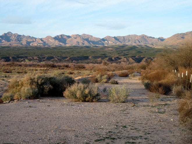
Further away from West Coast (east of the Sierra Mountains), it is easy to see giant high desert areas like the next photograph, where higher areas of sand, soils, and rock are strewn over miles and miles as receding waters topped and carved higher terrain, depositing large fans of rock, soils, and sand to lower areas.
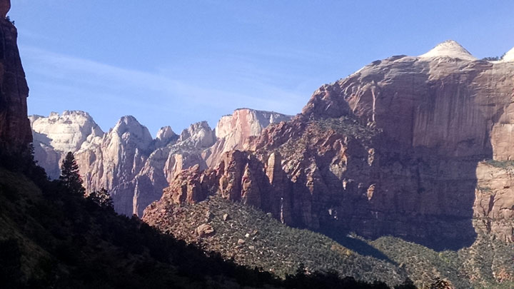
Some uplifted areas were carved by violent and deep waters. These forces were instrumental in the formaion vertical cliffs that stand out to the eyes in many locations. The next picture comes from an area in Zion National Park. Other canyons, like the Grand Canyon, were carved through sediments and rock to form deep canyons from what had been plateaus. At edges of higher areas, forceful waters caused lands to break away, which is the origin of the word “breaks” for an extraordinary topographic feature that marks many popular destinations for travelers. The “Cedar Breaks” are over 10000 feet above sea level!
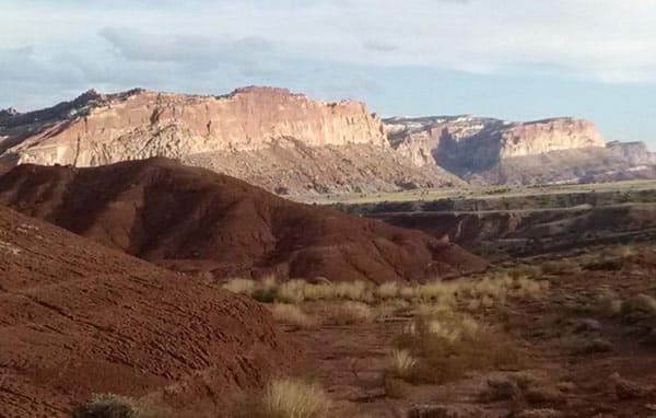
This picture below shows multiple lines of mountains that were sheered by huge water flows. The valley is miles wide and only has one small river. Think of the moving waters that did the work to sheer these mountains in the distance and round the hills in the foreground.
Today fans of debris and soils laid in the valleys or lower elevations are easily reachable and explorable. Huge rounded rocks in numerous locations show the results of debris filled waters moving and rounding them. As flows got shallow, the forces were not strong enough to carry them further, so they were “dropped” in places we can see first hand. Vertical cliff faces, which were mentioned above, abound in the Southwest. These faces and the curves in them defy explanations that point to a little stream or erosion over deep time. Layers of multicolored rock sediments are beautiful and plentiful. They were not deposited by anything less than a worldwide Flood event, then they were lifted and carved by receding waters so we can seen them. Mountains with tops missing speak of water forces moving agains them when they were still submerged. Forests that had been quickly “petrified” during the flood then deeply buried were subject to receding water flows that “unearthed” them. You can see remnants of this in the Pertrified Forest National Park or the adjacent Painted Desert.
The signs are awsome if you consider God’s statements about the Genesis flood as historical fact. But how can so many be wrong if this is true? You must remember, if you take God out of the equation as if He had nothing to do with either the origin of earth or its changes from the Genesis flood, then what He says in the Bible is relegated as myth. Add to this an assumption that the large earth features all happened slowly over deep time, then what alternative exists except evolution? Then only teach this conjecture for a century in most institutions and schools. No wonder a Bible view seems so strange!
But if you change your assumption and believe that He was involved, then the mountains of evidence of quick death and burial make perfect sense that is exhibited by topography and fossil evidence. Processes were so rapid and violent that whales are found fossilized together, yet sit at high altitudes in deserts. Tracks of dinosaurs show flight from rising flood waters–running in one direction for their lives. Jelly fish and other soft tissue things were fossilized. Violence! Awesome signs! Then the receding period and the centuries that immediately following the flood would be the time when receding and draining waters would cut huge canyons. Volcanism would lay lava flows over sand and sedimentary rock. These things are commonly seen from many highways in the Southwest.
Why are the observations of flood-altered geography important? Simple admonitions that are often repeated in the New Testament regarding the Genesis Flood become bold. They are often in passages that exhort believers to walk carefully as they consider the greatness of our God and warn of a second shaking that is coming. The topographic evidence serves to heighten awareness that He oversees the earth, watches the affairs of men, and has provided a Savior from our sins–the same kinds of sins that led to the culture of violence that yielded the Genesis Flood.
For more information and a study, download the free Creation Study from the <Downloadable Courses>. Also, use the search window at creation.com on some of the topics and processes mentioned in this article.
